There is quite a large market for PPC GPS applications of all kinds, so if Maverick is as well-thought-out as it looks from the screenshots and a PPC port is forthcoming, It’s almost certain to be successful to some degree.
What’s the difference between the lite and pro versions?
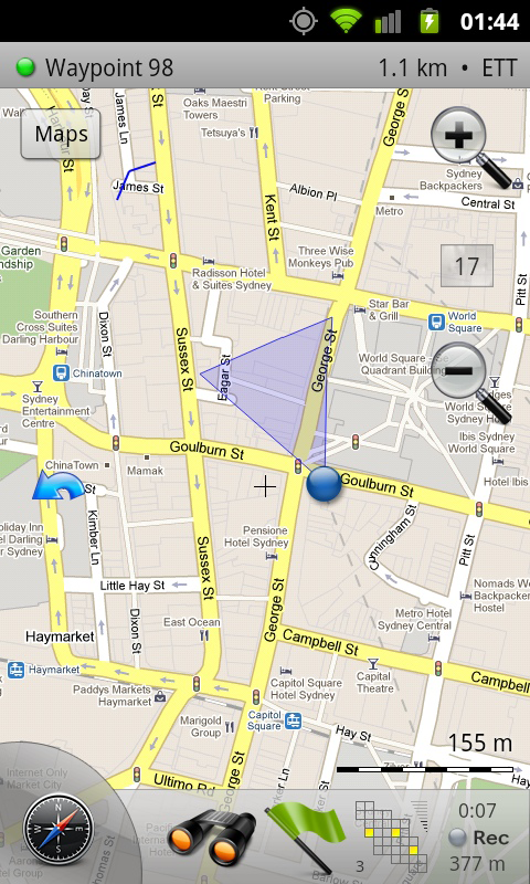
Also, what is the large shaded blue triangle that rotates around the “my location” icon on the map view?
One bug report so far: When set to “feet” unit, the “altitude” field in the trip computer page, and in the map page status bar comes out with too many digits of precision. Needs to be rounded off to fit in the box.
Suggestions:
1) Add nautical measurements also (knots and nautical miles).
2) And then add simple ‘routing’ facility, – setting/selecting waypoints on a map (land or sea) automatically and/or manually adding a sequence to the waypoints. This could make a simple routing and navigation feature for both land and sea. That a fully functonal navigation on sea. And I’m tired of traditional ‘Turn by turn’-navigation with voice-directions on land. I like a lot better to follow my position on a map where my planned route has been drawn by a pencil, like in real good old days 🙂 And this is what these suggestions could do electronically (Google maps can do some of it, but need all other functionality, that you already have, plus offline maps). With this you can combine same functionality for both sea and land. And outdoor trekking and possibly more.
3) Add feature for user specified selection and grouping of waypoints (family, friends, Great Belt Denmark, North Sea East, Customers, harbour-locations etc., – whatever).
4) Possibility to calibrate maps from images (JPG etc.). Either GPS-positions on upper left, lower right corner etc., or through additional known locations selected on the images, e.g. marine charts or other.
5) Then possibly, – as last and low priority, add ‘routing suggesting’-feature, similar to ‘Directions’ in Google map for Android, leaving a resulting ‘drawn’ route on a map, – no selecting/setting necessary, but same routing as used in suggestion 2).
@Ole E. Mikkelsen
Is it possible to export waypoints from e.g. Google Earth to Maverick?
I tried to transfer the ‘Waypoints.kml’ file from /sdcard/Maverick to GE which was OK. Then I added some new waypoints and transferred the file back, but they were not visible. How come ?
Ole E. Mikkelsen :@Ole E. Mikkelsen Is it possible to export waypoints from e.g. Google Earth to Maverick?
I tried to transfer the ‘Waypoints.kml’ file from /sdcard/Maverick to GE which was OK. Then I added some new waypoints and transferred the file back, but they were not visible. How come ?
Just to answer my own question, – it works, – just took me a little time before I found out. Negative altitudes in the ‘coordinates’-segment seems not allowed. The ‘name’-segment must conform to certain rules on naming. Possibly other segments in the Google Earth .KML file are not allowed in Maverick.
Having sorted these things out it works fine just pointing at a waypoint on the map, and then selecting this as a target. Brilliant for geocaching.
– And my item 4) above could be implemented also via Google Earth by means of the ‘map-overlay’ feature. Example KML-file below, specifying 4 corners of an image and also specifying transparency, so that both the google satellite images can be seen and the ‘non white’ areas og the ‘imagefile.jpg’.
In this way the program can store marine charts and other supplementary charts for an area.
Luckily I don’t know the technical challenges by my suggestion 🙂
Very nice application. Just moved form WM6.5 to Android (was rigth decision). Used “Glopus” in WM days. Vies, usability.. is now much better. Things I miss/propose for possible future releases:
1) Allow use of OSM Vector data for offline use (“Gmapsupp.img”). Losts of ready data on the web, well maintained. Whole Europe is then just 700kByte. Think this needs an rendering on board – but may be there are open source codes available from OSM guys
2) allow on map view to set target waypoint to next in list (“navigation lite”). Could help a lot in planning bike trips…
Thanks a lot for the good app.
frige
I just purchased Maverick because it looks like a very promising app for Hijing and Geocaching.
I just have a problem with inserting or editing waypoints. When I change the coordinates manually, all values jumps to zero.
It is also not possible to add Geocaching.com coordinates with the proposed method.
Bravo! Very well done! Nicest app on my phone! Perfect for all my needs! I’ve got the Lite version. The only bug I can find is an Altitude rounding problem.
Yvan :
I just purchased Maverick because it looks like a very promising app for Hijing and Geocaching.
I just have a problem with inserting or editing waypoints. When I change the coordinates manually, all values jumps to zero.
It is also not possible to add Geocaching.com coordinates with the proposed method.
Yvan.
Hi. Just bought Maverick pro. Great app, but have just tried using GPS tracking and it drained the battery from full to 10% in just 3 Hrs on my HTC Hero(t-mobile UK latest rom)! Any ideas? Was going to use this for my upcoming trip, but ‘My Tracks’ will win due to battery life.
Hi, I recently got a Samsung Galaxy i5700 and I have to say that I really like Google Andriod it is by far the best mobile os I have tried. The endless supply of great apps makes every day with my phone an adventure.Sorry for my wall of text I just wanted to share my experience with android. Have a great day and thanks for a great blog.
Hi
Bought the program a few weeks ago. I have one major gripe.
This app relies on a good cellphone internet connection.
It really needs a method of importing gpx or loc files which are downloaded from geocaching.com at home on the desktop then imported int the Maverick program for use in the wild. I know you can connect to geocaching.com on the phone but how do I import my pocket queries which might ciontain 200 caches?
There is little or no cellphone coverage in a number of wild areas I go geocaching. Other than the above it is a superb polished piece of software. I would like to see the program accept imports of say more 100 caches, would this be possible or does it already do it and i have missed the point?
Is it possible to use .imi maps like the ones that you use on Magellan Handheld GPS units?
Also, I can’t find an area to report bugs. I used Maverick on my wifi connection with Google Satellite layer and now all my local systems have problems with viewing satellite layer on Google maps. Are they blocking ip’s ? Does this software violate Googles terms of use?
I bought it last weak. but when I record a road I can actually see how many km’s I drove but when I export or try to upload my recorderd data I get the message that the file is empty and that there are no waypoints in the track?! Anyone kno wwhat the problem could be?
I have the same Problem :
I just have a problem with inserting or editing waypoints. When I change the coordinates manually, all values jumps to zero.
It is also not possible to add Geocaching.com coordinates with the proposed method.
I see the question, but not the answer. I live in Southeast Alaska. I would LOVE to use this app out on the water. Are you considering any nautical charts options? Thanks
@Jeff
I think it might have something todo with internationalization. The decimal delimiter in Germany p.ex. is the comma. Does the programm check input against a hard coded coordinate style?
I just switched my phone language from German to English (US) and manual coordinate input does work now! Use coordinates from geocaching does still not work 🙁
Maverick 1.2 has a bug which prevent the user from deleting waypoints and recorded routes. This bug is also exist in version 1.1.7. I tried Maverick pro on Hero and after that on Nexus and I’m getting the same bug on the two phone. Customer support is not supporting me at all. The site states that the update from 1.1.7 to a heigher version is fre
e yet the site is not explaining how to do that.
I’ve loaded up offline maps, and loaded in all my waypoints for a trip, but they waypoints show up on the map all the time, leaving the map display rather cluttered. Anyway to switch to showing no waypoints, only the waypoint you’re navigating to, and all waypoints?
Dear Jeff,
Can you advise me on adding .kmz overlay into Maverick? I have 2 overlays that I have converted into .kmz that I would like to view on my Nexus One as overlays on top of the other map choices. One is small and simple: vector data. The other one is a geologic map of 80mb.
Can I add a new map into Maverick? (from the geologic map) Can I make an overlay from my vector data?
Please let me know your thoughts and advise. Thanks for the great program.
I’m new to Android, Maverick etc. so may be just incompetence 😉
I have just downloaded the light version 1.2.0 (on HTC Desire). Things seem to be quite simple, and I’ve managed to figure out how most things work. I am using the OSM mapnik maps, and have a couple of problems with waypoints.
1) If I add a way point (pressing green flag) it appears in the waypoint list, but if I then delete it from the waypoint list, it is still visible on the screen.
2) If I select geocaching, and work through the process to add the geocache waypoint it doesn’t appear anywhere. All looks as expect until you return to the Maverick map screen, but at that point there is no sign of the waypoint :(.
I have this app for quite a while and likes it very much for its offline mode. The only regret I have is the database format used which is plain raw filesystem. Unless you have formatted your SD card with small chunk size, *you will waste a lot of SD space* and quickly run out of space. I would really appreciate a better, more compact, format such as a sqlite DB. I know that Mobile Atlas Creator can already export in this format for other apps. Any chance to have this in future release ?
DON’T buy this app! The lite version is awesome but the paid version is bogus. Promised features don’t work and support is just a pretend email address. Save your money and stick to the free version!
As we all know, if you download any quantity of detailed map tiles the storage requirement racks up quickly, and most phones only have a limited storage (especially once you put a few apps on). Is there anyway to move the folder structure with the tiles to my external SD card? I put 32GB sd card in the phone thinking I could use that for maps but I’m unable to find any option in the app (or any ini file) that i can point at “mntsdcardextrernal_sd”. I bough the paid version based on a user comment saying move to SD was now available, but that seems to only moves the app, the tile folder still gets created on the internal SD card. I’m wondering if this is actually a bug, and that move to SD should re-point the folders too?
Maverick uses getExternalStorageDirectory() function to get location of SD card. Android currently have no way to select between internal and external SD cards, I’ll need to add a manual selection for maps folder location.
Is available?. Where?. In the market?
Full version can be purchased from our site, lite version will be available in the Market later this month.
Until the end of this year, full version is free for our customers.
@Jeff
Where can I download this?
Will be available in Market in a few days.
Uploaded to Market.
http://www.cyrket.com/package/com.codesector.maverick.lite
Loving this. How to set up an offline map please?
Thanks, just wrote a small guide: http://help.codesector.com/MapsCache
Any chance of a WindowsMobile/PPC port?
There is quite a large market for PPC GPS applications of all kinds, so if Maverick is as well-thought-out as it looks from the screenshots and a PPC port is forthcoming, It’s almost certain to be successful to some degree.
@Jeff
Can you port it to nokia symbian V5 aswell, so N97, N900, 5800, and all the good ones!
Hi, I tried setting the offline maps for Maverick. I followed the exact procedure, as described by the second method.
1. Download
2. Rename to TILE
3. Copy all to the “tiles/mapnik”-folder
But when I try to use Maverick with internet turned off, it won’t load any maps that weren’t downloaded before? I did keep all the subfolders etc.
Looks very good; added to the Android Users Howto Wiki, in the Maps/GPS/geocaching section.
Awesome app! Just what I’ve been looking for.
What’s the difference between the lite and pro versions?
Also, what is the large shaded blue triangle that rotates around the “my location” icon on the map view?
One bug report so far: When set to “feet” unit, the “altitude” field in the trip computer page, and in the map page status bar comes out with too many digits of precision. Needs to be rounded off to fit in the box.
Yes, wonderful program 🙂
Suggestions:
1) Add nautical measurements also (knots and nautical miles).
2) And then add simple ‘routing’ facility, – setting/selecting waypoints on a map (land or sea) automatically and/or manually adding a sequence to the waypoints. This could make a simple routing and navigation feature for both land and sea. That a fully functonal navigation on sea. And I’m tired of traditional ‘Turn by turn’-navigation with voice-directions on land. I like a lot better to follow my position on a map where my planned route has been drawn by a pencil, like in real good old days 🙂 And this is what these suggestions could do electronically (Google maps can do some of it, but need all other functionality, that you already have, plus offline maps). With this you can combine same functionality for both sea and land. And outdoor trekking and possibly more.
3) Add feature for user specified selection and grouping of waypoints (family, friends, Great Belt Denmark, North Sea East, Customers, harbour-locations etc., – whatever).
4) Possibility to calibrate maps from images (JPG etc.). Either GPS-positions on upper left, lower right corner etc., or through additional known locations selected on the images, e.g. marine charts or other.
5) Then possibly, – as last and low priority, add ‘routing suggesting’-feature, similar to ‘Directions’ in Google map for Android, leaving a resulting ‘drawn’ route on a map, – no selecting/setting necessary, but same routing as used in suggestion 2).
Thanks for letting me sending you my ideas 🙂
Ole
@Ole E. Mikkelsen
Is it possible to export waypoints from e.g. Google Earth to Maverick?
I tried to transfer the ‘Waypoints.kml’ file from /sdcard/Maverick to GE which was OK. Then I added some new waypoints and transferred the file back, but they were not visible. How come ?
Just to answer my own question, – it works, – just took me a little time before I found out. Negative altitudes in the ‘coordinates’-segment seems not allowed. The ‘name’-segment must conform to certain rules on naming. Possibly other segments in the Google Earth .KML file are not allowed in Maverick.
Having sorted these things out it works fine just pointing at a waypoint on the map, and then selecting this as a target. Brilliant for geocaching.
– And my item 4) above could be implemented also via Google Earth by means of the ‘map-overlay’ feature. Example KML-file below, specifying 4 corners of an image and also specifying transparency, so that both the google satellite images can be seen and the ‘non white’ areas og the ‘imagefile.jpg’.
In this way the program can store marine charts and other supplementary charts for an area.
Luckily I don’t know the technical challenges by my suggestion 🙂
Thanks for letting me comment 🙂
Map headline name
57ffffff
imagefilename.jpg
0.75
9.525,55.5,0 10.66666666666667,55.5,0 10.66666666666667,55.93333333333333,0 9.525,55.93333333333333,0
sorry I forgot about html-reserved letters.
‘GroundOverlay’
‘name’Map headline name’/name’
‘color’57ffffff’/color’
‘Icon’
‘href’imagefilename.jpg’/href’
‘viewBoundScale’0.75’/viewBoundScale’
‘/Icon’
‘gx:LatLonQuad’
‘coordinates’
9.525,55.5,0 10.66666666666667,55.5,0 10.66666666666667,55.93333333333333,0 9.525,55.93333333333333,0
‘/coordinates’
‘/gx:LatLonQuad’
‘/GroundOverlay’
Wonderfull app!
But i’ve been missing a auto-following/center option in the map.
Thank-you
Very nice application. Just moved form WM6.5 to Android (was rigth decision). Used “Glopus” in WM days. Vies, usability.. is now much better. Things I miss/propose for possible future releases:
1) Allow use of OSM Vector data for offline use (“Gmapsupp.img”). Losts of ready data on the web, well maintained. Whole Europe is then just 700kByte. Think this needs an rendering on board – but may be there are open source codes available from OSM guys
2) allow on map view to set target waypoint to next in list (“navigation lite”). Could help a lot in planning bike trips…
Thanks a lot for the good app.
frige
I just purchased Maverick because it looks like a very promising app for Hijing and Geocaching.
I just have a problem with inserting or editing waypoints. When I change the coordinates manually, all values jumps to zero.
It is also not possible to add Geocaching.com coordinates with the proposed method.
Yvan.
Great app for land. I also vote for nautical units (knots and nautical miles), will definetly buy the app, if it will have support for those units.
I agree, support for nautic units and bsb charts and I will que up for a copy.
Bravo! Very well done! Nicest app on my phone! Perfect for all my needs! I’ve got the Lite version. The only bug I can find is an Altitude rounding problem.
Same problem here.. hope this will be fixed soon!
Please test new version and email me in case of errors. Including detailed description and info about your device/ROM will be very helpful.
great app.
i am also interesting for nautical charts of adriatic sea.
is it possible in future ?
Hi,
You mention the full version is free for users this year?
How do I download it?
Thanks
Hi. Just bought Maverick pro. Great app, but have just tried using GPS tracking and it drained the battery from full to 10% in just 3 Hrs on my HTC Hero(t-mobile UK latest rom)! Any ideas? Was going to use this for my upcoming trip, but ‘My Tracks’ will win due to battery life.
thanks
Sorry for my late reply. Same problem exist with the new version. I have a HTC hero (Android with Sense skin).
How does one delete waypoints?
Hi, I recently got a Samsung Galaxy i5700 and I have to say that I really like Google Andriod it is by far the best mobile os I have tried. The endless supply of great apps makes every day with my phone an adventure.Sorry for my wall of text I just wanted to share my experience with android. Have a great day and thanks for a great blog.
Hi
Bought the program a few weeks ago. I have one major gripe.
This app relies on a good cellphone internet connection.
It really needs a method of importing gpx or loc files which are downloaded from geocaching.com at home on the desktop then imported int the Maverick program for use in the wild. I know you can connect to geocaching.com on the phone but how do I import my pocket queries which might ciontain 200 caches?
There is little or no cellphone coverage in a number of wild areas I go geocaching. Other than the above it is a superb polished piece of software. I would like to see the program accept imports of say more 100 caches, would this be possible or does it already do it and i have missed the point?
Cheers
Mike
Great app.
Is it possible using my ???.img (Garmin format), or ???.ntm (navitel format), or ???.rus (russa format) maps on maverick?
Great app!
Is it possible to use .imi maps like the ones that you use on Magellan Handheld GPS units?
Also, I can’t find an area to report bugs. I used Maverick on my wifi connection with Google Satellite layer and now all my local systems have problems with viewing satellite layer on Google maps. Are they blocking ip’s ? Does this software violate Googles terms of use?
I bought it last weak. but when I record a road I can actually see how many km’s I drove but when I export or try to upload my recorderd data I get the message that the file is empty and that there are no waypoints in the track?! Anyone kno wwhat the problem could be?
I have the same Problem :
I just have a problem with inserting or editing waypoints. When I change the coordinates manually, all values jumps to zero.
It is also not possible to add Geocaching.com coordinates with the proposed method.
My Andoid Phone is HTC Magic with cyanogenMOD
Course made good or velocity made good would complete this app for me
I see the question, but not the answer. I live in Southeast Alaska. I would LOVE to use this app out on the water. Are you considering any nautical charts options? Thanks
@Jeff
I think it might have something todo with internationalization. The decimal delimiter in Germany p.ex. is the comma. Does the programm check input against a hard coded coordinate style?
I just switched my phone language from German to English (US) and manual coordinate input does work now! Use coordinates from geocaching does still not work 🙁
Still trying to find out what the blue triangle is?!?!? Any help?
It’s on the main map page and it rotates around the center point. I can’t seem to figure out what it’s supposed to be pointing at.
upload to gpsies.com not working
Maverick 1.2 has a bug which prevent the user from deleting waypoints and recorded routes. This bug is also exist in version 1.1.7. I tried Maverick pro on Hero and after that on Nexus and I’m getting the same bug on the two phone. Customer support is not supporting me at all. The site states that the update from 1.1.7 to a heigher version is fre
e yet the site is not explaining how to do that.
I’ve loaded up offline maps, and loaded in all my waypoints for a trip, but they waypoints show up on the map all the time, leaving the map display rather cluttered. Anyway to switch to showing no waypoints, only the waypoint you’re navigating to, and all waypoints?
@LazySumo
I believe the blue triangle is a rough estimate of the direction you’re facing, based on the electronic compass in your phone.
Dear Jeff,
Can you advise me on adding .kmz overlay into Maverick? I have 2 overlays that I have converted into .kmz that I would like to view on my Nexus One as overlays on top of the other map choices. One is small and simple: vector data. The other one is a geologic map of 80mb.
Can I add a new map into Maverick? (from the geologic map) Can I make an overlay from my vector data?
Please let me know your thoughts and advise. Thanks for the great program.
I’m also interested!
I’m new to Android, Maverick etc. so may be just incompetence 😉
I have just downloaded the light version 1.2.0 (on HTC Desire). Things seem to be quite simple, and I’ve managed to figure out how most things work. I am using the OSM mapnik maps, and have a couple of problems with waypoints.
1) If I add a way point (pressing green flag) it appears in the waypoint list, but if I then delete it from the waypoint list, it is still visible on the screen.
2) If I select geocaching, and work through the process to add the geocache waypoint it doesn’t appear anywhere. All looks as expect until you return to the Maverick map screen, but at that point there is no sign of the waypoint :(.
very good map , fast and detaild . but must have turen by turen option and voice nevigation . any suggest ?
This is more for offroad type usage so hence no turn by turn/voice guidance.
You can import Google data by using a convertor utility to turn the KML into a GPX file format.
Get your maps using Mobile Atlas Creator:-)
This app is actually very usable and I think a giveaway for $5!!!!!
I have this app for quite a while and likes it very much for its offline mode. The only regret I have is the database format used which is plain raw filesystem. Unless you have formatted your SD card with small chunk size, *you will waste a lot of SD space* and quickly run out of space. I would really appreciate a better, more compact, format such as a sqlite DB. I know that Mobile Atlas Creator can already export in this format for other apps. Any chance to have this in future release ?
DON’T buy this app! The lite version is awesome but the paid version is bogus. Promised features don’t work and support is just a pretend email address. Save your money and stick to the free version!
This is great map app for android os.
Hi,
As we all know, if you download any quantity of detailed map tiles the storage requirement racks up quickly, and most phones only have a limited storage (especially once you put a few apps on). Is there anyway to move the folder structure with the tiles to my external SD card? I put 32GB sd card in the phone thinking I could use that for maps but I’m unable to find any option in the app (or any ini file) that i can point at “mntsdcardextrernal_sd”. I bough the paid version based on a user comment saying move to SD was now available, but that seems to only moves the app, the tile folder still gets created on the internal SD card. I’m wondering if this is actually a bug, and that move to SD should re-point the folders too?
Help!
Tim
Maverick uses getExternalStorageDirectory() function to get location of SD card. Android currently have no way to select between internal and external SD cards, I’ll need to add a manual selection for maps folder location.